The Recchia Home, 6 Summer St., Rockport, 1906

SixSummerStreet-post

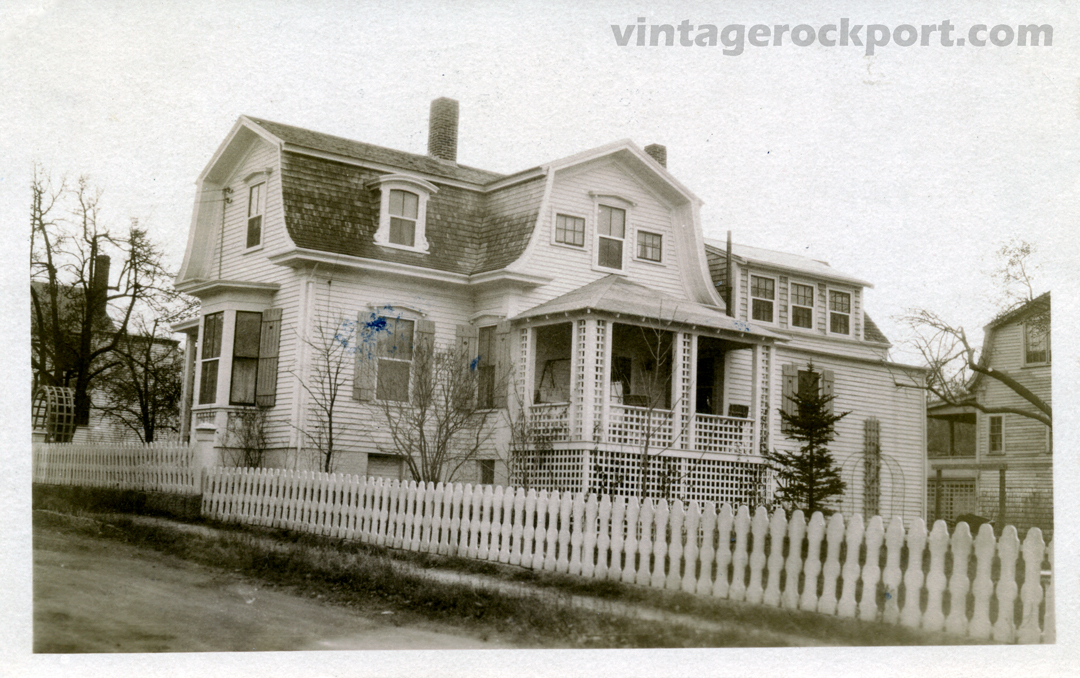
Everyone in Rockport knows the iconic statue of a baby riding a frog that stands adjacent to the Rockport Art Association on Main Street. The sculptor and portrait artist who created that piece, Richard H. Recchia, and his wife, the writer and artist Kitty Parsons Recchia, lived in this home at 6 Summer St., where they also built a studio. The Recchias called the house “Hardscrabble.” Both the home and the studio are still there.

Baby and Frog

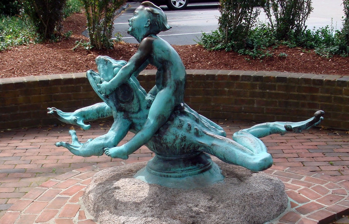
Recchia’s “Baby and Frog” is outside the Rockport Art Association. Another version is in Brookgreen Gardens in Myrtle Beach, S.C.

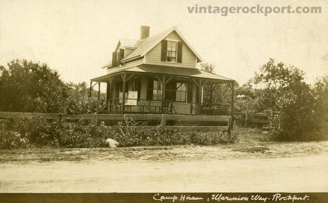
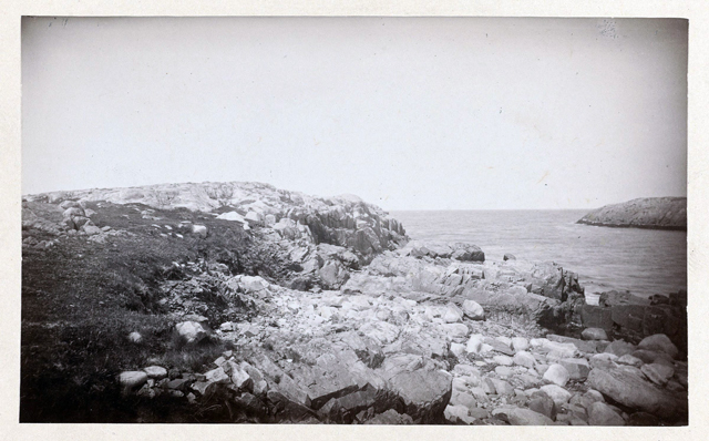
The house was built in 1837, according to online real estate records. Parsons, who was born in 1889 in Stratford, Conn., first lived here with her family before she met Recchia. Her family summered in Gloucester before they moved to this house. They probably already lived here when this photograph was taken. In fact, the postcard is signed, “Kitty,” and could have come from her.

It was in Rockport that Parsons met her future husband. Recchia was born in 1885 in Quincy, Mass. His father, a marble carver from Verona, Italy, taught the young Recchia to sculpt. From 1904 to 1907, Recchia attended the school of the Museum of Fine Arts in Boston, and continued to work there until 1912 as an assistant to the sculptor Bela L. Pratt. It appears that he moved to Rockport sometime around 1926 and married Kitty in 1927.

(Before he came to Rockport, he was married to another woman, Anita, who he met while living in Paris, and with whom he had two children. In this oral history recording from 1978, he said that he was married to Anita until 1926, when she died. However, his recollection of some dates does not always comport with other records.)

IMG_0086

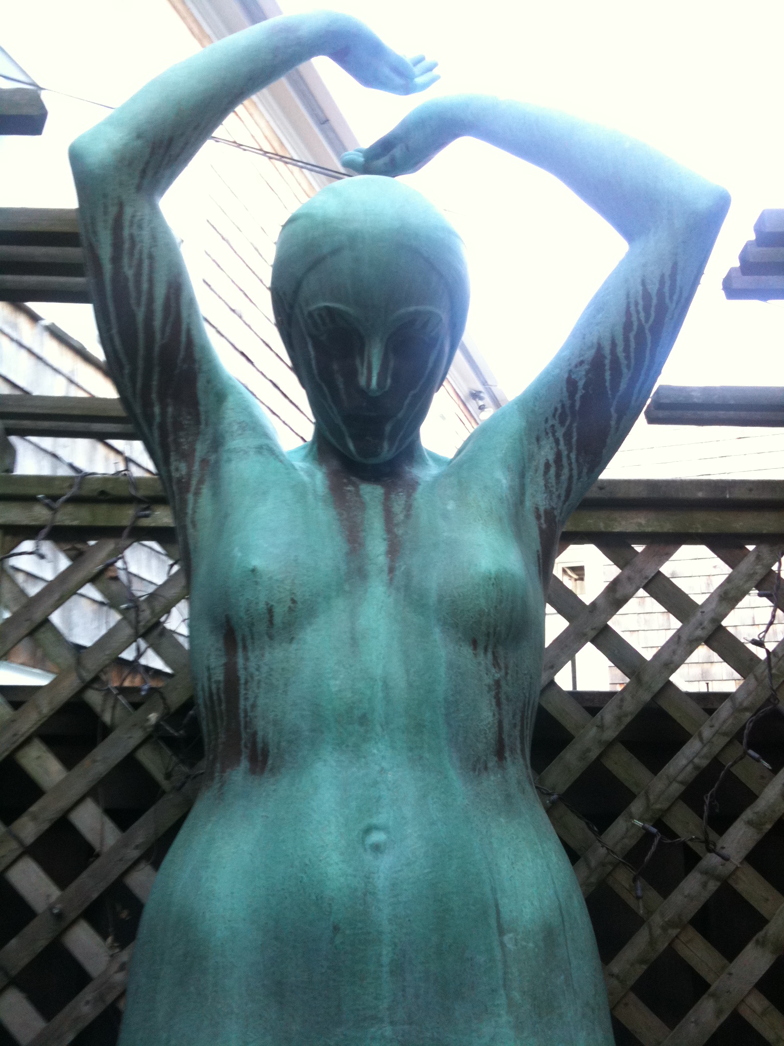
Recchia’s diver is behind the Rockport Art Association

One of his best-known works is the mammoth statue of Revolutionary War hero General John Stark that stands near his grave in Manchester, N.H. His statue “Mother Goose” stood in the children’s room of the old Carnegie Library until it closed in 1993. (I can find no record of where the statue went after that.) His bronze statue of a woman about to dive stands behind the Rockport Art Association. For many years, it was in his studio and then in his yard.

Kitty Parsons was a founding member of the Rockport Art Association in 1920 and editor of Artists of the Rockport Art Association published in 1940. Other books she wrote include Dogtown Commons (1936), Buccaneer Ballads and Legends of Cape Ann and Essex County (1944), Gloucester Sea Ballads: True Tales of Fishermen (1948), and Christmas Offering (1956).

Kitty Parsons died in 1975. Recchia continued to live in the house until his death in 1983. He is buried at Rockport’s Beech Grove Cemetary, under a tombstone he carved for himself before his death.

For an in-depth article about this house and its famous occupants, see the post about it at The Landmark Files. To hear Recchia talk about his life, listen to these oral history recordings.

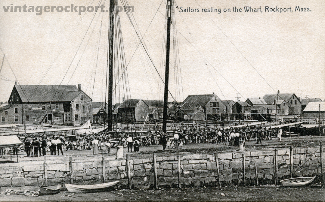
As to the postcard, it was a real-photo postcard made from an actual photo negative. As I noted above, it was signed by someone named “Kitty,” quite possibly Kitty Parsons herself. It was postmarked on Feb. 10, 1906, when Kitty would have been around 17.

Posted in Uncategorized | 3 Comments

Headrock Beach (Old Garden), Rockport, Mass., c. 1937

Headrock-Beach-post

I have sometimes seen Old Garden Beach called by the name on this postcard, Headrock Beach. Perhaps the name is from the large, head-shaped rock that sits near the beach’s far end.

As you may be able to see from the texture in this image, this is a linen postcard. Postcards with this linen-embossed texture were popular from the 1930s to the early 1950s and often had vivid colors such as this.

This postcard was published by H. C. Brown Inc. in Gloucester. It was printed by Tichnor Brothers, a Boston publishing company that was in business from 1912 to 198. The card is postmarked 1950 but I have seen the identical card with a 1940 postmark. For that reason, I estimate its date to be roughly 1937.

Posted in Uncategorized | Tagged | 2 Comments

Gap Cove, Rockport, Mass., circa 1915

Gap-Cove-Rockport-post

This view is looking from Straitsmouth Point across Gap Cove, with the Twin Lights of Thacher Island in the distance. The Straitsmouth Inn would have been a bit farther down the road to the left. The two shed-like buildings were probably part of the inn.

I’ve posted another postcard from this same publisher, Grafton Butman, showing a view that would have been from just a little farther down along this same road. That view showed the Straitsmouth Inn’s tennis courts and the view across Gap Cove to Straitsmouth Island.

Although I estimated that image to be from around 1919, the one above was postmarked in 1916, so the photograph was likely taken in 1915 or earlier.

Below is a photograph of roughly the same scene today. As you can see, the low popplestone wall is still there. The house on the far side of the cove has been replaced by a more modern structure.

IMG_2705-post

Posted in Uncategorized | Tagged , , , , | 3 Comments

Found on the Web: Gap Head and Straitsmouth, 1888

Gap-Head-1888_post

This 1888 photograph is described as a view of Rockport Point with Straitsmouth Island in the background. This point is more commonly known as Gap Head or Straitsmouth Point. What is remarkable about this view is that it is before any buildings were constructed on the point. The life saving station at Gap Cove was built a year after this picture was taken. The Straitsmouth Inn, which stood at the tip of this point, was built in 1906.

The photo below shows today’s view of Gap Head to the left and Straitsmouth Island to the right. I was not able to get to the location where the above photo was taken without going into someone’s backyard (or maybe even into someone’s house).

IMG_2699_cut

Posted in Uncategorized | Tagged , , | 3 Comments

The Old Log Cabin, at the Foot of Cove Hill, Oldest House in Rockport, Mass.

The-Old-Log-Cabin-post

The postcard identifies this house — which still stands at the corner of Mt. Pleasant Street and Atlantic Ave. — as the oldest house in Rockport. The plaque that is on the house now says it was built in 1680 by Joshua Norwood, father of Caleb. But based on what I read, the house is not the oldest in Rockport, was not built in 1680, and was not built by Joshua Norwood.

IMG_2678-cut

A similar view of the house today.

According to the History of the Town of Rockport, published in 1888, this house was built by Caleb Norwood, Joshua’s son, on land adjacent to Gap Cove.

“[The] house, on the corner of Mt. Pleasant St. and Atlantic Avenue, according to tradition, is the house built by Caleb and removed to its present position about eighty years ago,” the history says.

IMG_2677_cut

The view from the corner of Mt. Pleasant and Atlantic Ave.

Joshua Norwood and his family moved to Gap Cove around 1740 (different sources give different dates). Joshua first moved to Pigeon Cove in 1694, so he did not even live in the area at the time the plaque says he built the house. For many years, he and his family (he and his wife had 14 children) lived in what is now known as the Witch House. It appears that the family moved out of the area for a time, to Attleboro, Mass., and settled in Gap Cove when they returned.

Caleb was born  in 1736 so the house would not have been built until some years after that, presumably when he was a young man. That would mean it was built closer to 1755 or so. Based on the history’s account, it would have been moved to its present location around 1800.

IMG_2679_cut

This plaque is on the house.

Caleb is famous around Rockport as the boy who supposedly discovered pirates’ treasure at Gully Cove in 1752. (Eleanor Parson’s  book, Rockport: The Making of a Tourist Treasure, says he was 13 at the time, but all records I find say he was born in 1736, which would mean he was 16 in 1752.) Thanks to the treasure, he grew up to be a wealthy man and built several houses. As I’ve previously noted, one is the Headland House on Norwood Avenue, which he build in 1781 and which later became the home of artist Harrison Cady.

This postcard was published by the Rockport Photo Bureau. I estimate the date of the postcard to be approximately 1925.

Posted in Uncategorized | 4 Comments

Sailors Resting on the Wharf, Rockport, Mass., circa 1906

Sailors-Resting-post

Sailors line the north side of T-Wharf as a small number of curious onlookers watch them. Behind them, a two-masted schooner is docked at the wharf, but I doubt the schooner had any relation to these sailors. More likely, the sailors were ashore off one of the warships that regularly visited Rockport in those days, and the schooner was one of the granite schooners that regularly tied up there.

Although the caption identifies these men as sailors, most appear to be wearing a khaki-colored uniform that looks more like a Marine or Army uniform from the period. I’m no expert in military apparel, but I IMG_2675-cuthave to wonder if these men are Marines.

In the background to the left of the postcard, you can see the large building at the foot of Bearskin Neck that still stands there today, as you can see from the photo to the right. Just to the left of this building in the early 1900s was Waddell’s boat yard. I think this building was part of Waddell’s.

This postcard was published by The Rotograph Co. of New York City and was printed in Germany. The company was in business only from 1904 to 1911.

Posted in Uncategorized | Tagged , , , | 4 Comments

Blondon, Bay View, c. 1915 (In Honor of Barbara Erkkila)

Blondon-Bay-View-post

I was sorry to learn about the death this week of Barbara Erkkila. A longtime journalist and historian, her 1980 book, Hammers on Stone: The History of Cape Ann Granite, is the definitive account of granite quarrying in Gloucester and Rockport.

Hammers on StoneHad I not read Barbara’s book, I might never have known what a “blondon” was, the contraption shown in this scene from one of the quarries in the Bay View section of Gloucester. A blondon was a cable running between two wooden (later metal) towers that was used to lift and move the big blocks of granite cut from the quarry. Here is Barbara’s description:

The moved those great stones by an aerial lift arrangement of cables between two wooden towers that they called a ‘blondin.’ The terms was evidently in honor of the French acrobat, Charles Blondin (real name Jean Francois Gravelet). The Frenchman had nonchalantly walked across a rope at Niagara Falls about 1860, stopping halfway to make an omelette on a stove he had brought along on his back. He lowered the cooked egg dish to the people on the Maid of the Mist tourist steamer far down below him. Then, picking up the stove once more, he continued on his way across the rope to the opposite side. Thousands watched him, their mouths open in disbelief.

Note that the postcard spelled it “blondon” and Barbara spelled it “blondin.” Searching both words online, I found an article about a quarry in England in the late 1800s and early 1900s that used blondon, with the “o.” But a Wikipedia entry uses the “blondin” version that Barbara used, also identifying tightrope walker Charles Blondin as the source of the name. It says that the first known use of blondins in the quarry industry was in Wales in 1913.

This postcard has no information on the reverse that identifies the publisher or date, except that it appears to be from before 1917.

Posted in Uncategorized | Tagged | 1 Comment

Streets that Have Disappeared Around Marmion Way

In writing my last post about a Marmion Way cottage, I looked at a map of the area from 1899. I was surprised to see that it contained several streets that no longer exist. Compare the two views below, one from the 1899 map and the other from today’s Google Earth. If you look carefully, you will see streets on the old map that have disappeared entirely. They include:

  • Glencoe Road, which ran from what is now called Lighthouse Lane (across from Gully Point Cove) over to Straitsmouth Way. Today there is a short road off Straitsmouth, Stone Haven Lane, that may be a remnant of Glencoe.
  • Clydesdale Road, which ran from Whale Cove straight across to where Marmion intersects with Old Garden Road. It appears that today’s Richards Avenue was formerly part of Clydesdale. I found a 2008 town of Rockport document that shows Clydesdale as still running between Straitsmouth and Marmion.
  • Between Clydesdale and Marmion are several streets — Grampian, Cheviot and Rokeby, that have all disappeared.

Do any readers remember any of these streets or know what became of them?

Marmion1899

Marmion2013

Posted in Uncategorized | 1 Comment

Marmion Way Cottage, Rockport, Mass., circa 1912

Marmion-Way-Cottage-Post This is a real-photo postcard printed directly onto photographic paper, not a commercially printed postcard. It shows a cottage on Marmion Way in Rockport. The handwritten inscription appears to say, “Camp House, Marmion Way, Rockport,” although the second word is not clearly legible.

The brand of photographic paper on which this was printed was produced from 1907 to 1917, so the image is from sometime within that span.

Marmion Way was originally called Estes Avenue, after Alden Estes, who lived on South Street.

Posted in Uncategorized | Tagged | 3 Comments

The Orchard Restaurant and Tea Room, Rockport, Mass., c. 1934

The-Orchard-Restaurant-post

The Orchard Restaurant and Tea Room stood at 48 Beach St., across from Back Beach, in a building that is now a private residence. The sign above the entrance says, “The Orchard, Lobster & Chicken Dinners, Luncheons.” Below that hangs a sign that says, “Open.” To the left of the picture, by the stone wall, is another sign that says, “Parking for Guests Only.”

48 beach st

Google Street View of the property today.

I previously published another card that mentioned The Orchard, but this is the first postcard I’ve ever found that shows it directly.

In fact, I have not been able to find anything else about the restaurant. Other than knowing that it operated in the 1930s, I do not know who ran it or for how long it ran. If any readers have more information, please share it in a comment below.

I did hear from a family that purchased this property earlier this year. They shared that, in clearing the property, they found a small stone building that had an “Office” sign hanging outside the door.

The building was constructed in 1930, according to its listing on Zillow.

This card was published by the Rockport Photo Bureau. I suspect that this photo was taken on the same day as the other card I mentioned above and a third card. As I noted before, the two earlier cards both appear to show the same man sitting on the bench. All three postcards have identical printing on the reverse side, suggesting they were all produced during the same time period.

None of the cards are dated, so I cannot be certain about the year, but I think that the mid-1930s is safe estimate.

Posted in Uncategorized | Tagged , | 1 Comment