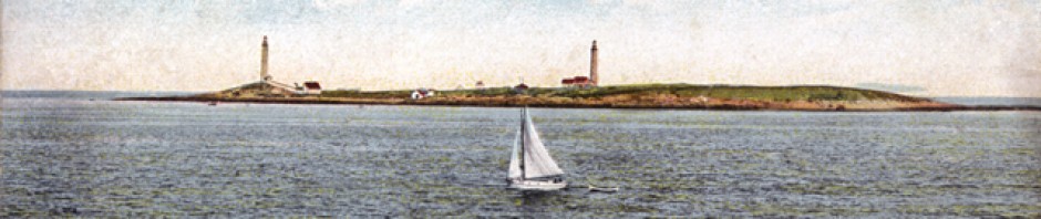

Unfortunately, the view that an author once described as “excelled nowhere on the New England coast” can no longer be seen. The summit of Pigeon Hill, the highest point in Rockport, is overgrown with vegetation that obstructs what was once a panoramic view in virtually every direction.
That description of the view came from Henry C. Leonard in his 1873 book, Pigeon Cove and Vicinity. Here is what he said:
[T]he prospect from Pigeon Hill is excelled nowhere on the New England coast. On this height, the eye takes in a portion of Massachusetts Bay; Sandy Bay, between the horns of the Cape; the broad offing of the ocean; Ipswich Bay, and the long coast of hills, headlands, and beaches from the Chebacco River to Agamenticus; and the Buttercups, dark blue hills near the ancient town of York, in Maine. Other objects belong to this prospect: on the right hand, the village of Rockport; farther toward Gap Head, Norwood’s Head; Gap Head and Straitsmouth Island; and southward from these points, Thatcher’s Island and Milk Island; in front, three miles from the base of the hill, the Salvages, bare, savage rocks, with heads just lifted above the water, wearing a fitting name, albeit as it was anciently spelled and written; around the foot of the hill, the beginning of the village of Pigeon Cove as it is approached from Rockport; on the left hand, close to the foot of the hill, Pigeon Cove Harbor, with its breakwater, wharves and shipping, and its collection of buildings; the post-office, several stores, a few stone-workers’ sheds, groups of fish-houses, and a score of dwellings; farther northward, on ascending ground, the continuation of the village, comprising the comely church and the spacious and pleasant summer hotels and boarding-houses; farther still, northward, Andrews’ Point, the northern termination of the Cape, partly clad with hardy oaks, walnuts and pines, and laid out with winding avenues and gravelled walks, like a park; besides, more than a score of miles from Andrews’ Point, the Isles of Shoals; then far away on the main land, the villages of Essex and Ipswich; Indian Hill, in Newbury; Powow Hill, in Amesbury; and Newburyport, on the Merrimack. Thus are pointed out some of the grander general outlines, and some of the finer marks and dots of the prospect from Pigeon Hill, as seen by the observer on this height in the present day.
According to a 2005 state government report, the Sandy Bay Historical Society, which owns part of Pigeon Hill, “is interested in re-establishing the historic views from the hill.” I do not know whether anything more has come of that idea.
This postcard was published by the Rockport Photo Bureau. I am not sure of the date, but I read somewhere that the Hotel Edward did not get that name until 1913, so I am estimating this to be around 1915.

Pingback: The Old Lane up Pigeon Hill, Pigeon Cove, Mass., circa 1915 | Vintage Rockport
Pingback: Pigeon Hill, Back When it was ‘Bald,’ circa 1915 | Vintage Rockport
I remember being able to see the ocean from the top of Pigeon Hill when I was a kid, 50 years ago.
I would love to get it cleared of trees to bring back the view.
When I was a teenager, we had picnics up there…it was beautiful.